

There’s a particular stretch of Nova Scotia’s Annapolis Valley where the past feels unusually close. The dyked farmlands, the tidal flats, the quiet rural roads between Wolfville and Grand-Pré – all of it carries the weight of several centuries in a way that feels lived in rather than staged. This is not just scenic countryside. It’s one of the most historically significant corridors in Canada, shaped by Indigenous peoples, French settlers, British colonial forces, and generations of farmers who kept working the same soil long after the political storms passed.
What makes this region compelling is how its physical landscape and its human story remain inseparable. The dykes the Acadians built still protect farmland today. The place names still carry French origins. The grief and the resilience of a displaced people are still the reason visitors travel here from across North America and beyond.
A Land Called Grand-Pré: “The Great Meadow”
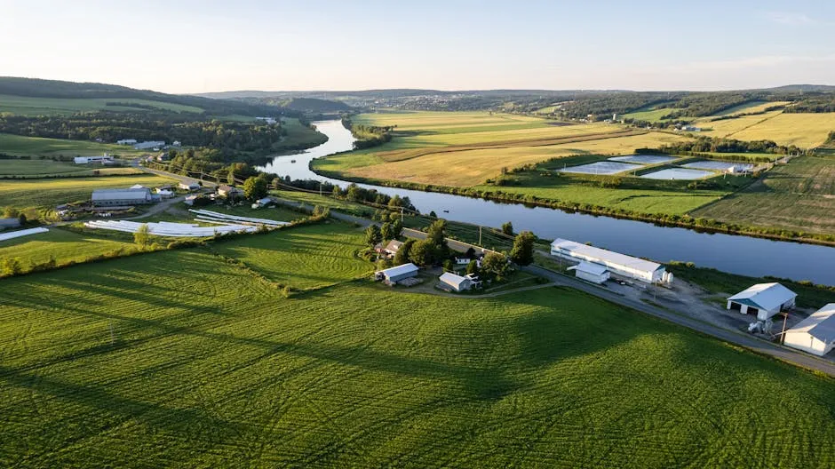
Grand-Pré’s French name translates to “Great Meadow,” and the community lies at the eastern edge of the Annapolis Valley, on a peninsula jutting into the Minas Basin, surrounded by extensive dyked farm fields framed by the Gaspereau and Cornwallis Rivers. The name fits perfectly. Standing at the edge of those open fields today, with the Bay of Fundy shimmering in the distance, the scale of what the Acadians once built here becomes genuinely impressive.
Grand-Pré is located on the shore of the Minas Basin, an area of tidal marshland, first settled about 1680 by Pierre Melanson dit La Verdure, his wife Marguerite Mius d’Entremont and their five young children, who came from nearby Port-Royal, which was the first capital of the French settlement of Acadia. From that single family’s arrival, an entire agricultural civilization would grow.
Grand-Pré became the breadbasket of Acadia, soon outgrew Port-Royal, and by the mid-18th century was the largest of the numerous Acadian communities around the Bay of Fundy and the coastline of Nova Scotia. That trajectory, from a single settler family to a thriving regional hub within just a few decades, speaks to both the fertility of the land and the ingenuity of the people who worked it.
The Acadians and Their Ingenious Dyke System

The Grand-Pré marshland and archaeological sites constitute a cultural landscape bearing testimony to the development of agricultural farmland using dykes and the aboiteau wooden sluice system, started by the Acadians in the 17th century and further developed and maintained by the Planters and present-day inhabitants. The aboiteau was a simple but brilliant invention: a one-way wooden valve embedded in the dyke that allowed fresh water to drain freely while blocking the incoming tide.
These dykes featured clapper valves which allowed a one-way water flow; fresh water which irrigated the fields flowed freely into the bay while rising seawater was prevented from entering. From the 1630s to 1755, an estimated 13,000 acres of salt marshes were dyked by the Acadians. That’s a staggering engineering achievement for a pre-industrial farming community.
The Acadians were the first people in North America to establish their settlements by transforming intertidal zones using the innovative aboiteau technology to take advantage of the fertile salt marshes for agriculture. Their approach to land use was so effective that it remained the dominant agricultural model in the region for centuries after their deportation.
Wolfville: From Mud Creek to University Town

Incorporated as a town in 1893, Wolfville was originally settled by the Acadians who were expelled by British forces in 1755. The area was resettled by New England Planters who arrived in 1760. The town’s origins are modest. It grew around a tidal harbour on the Cornwallis River, known for years as Mud Creek – a name that, as local history notes, was eventually changed.
In 1830, the town of Mud Creek changed its name to Wolfville, in honour of Elisha DeWolf, the town’s postmaster at the time. In 1838, Acadia University was founded as a Baptist college, and the institution has remained central to the town’s character ever since. Wolfville is very much a university town today, with the energy that comes with it.
Wolfville is a Canadian town in the Annapolis Valley, Kings County, Nova Scotia, located about 100 kilometres northwest of the provincial capital, Halifax. The town is home to Acadia University and Landmark East School. The town is a tourist destination due to its views of Cape Blomidon, the Bay of Fundy and Gaspereau Valley, as well as its wine industry. Its compact, walkable scale makes it easy to spend a full day simply wandering between landmarks.
The Bay of Fundy: Shaping Everything

The Bay of Fundy has the highest tidal range in the world, averaging about 16 metres due to tidal resonance in its funnel-shaped basin. That single fact defines much of what this region is and always has been. The tides don’t just fill in the background – they determine what can be farmed, where settlements can grow, and how people move through the landscape.
In one half-day tidal cycle, around 100 billion tonnes of water flows in and out, twice the combined flow of all the world’s rivers. The site is marked by one of the most extreme tidal ranges in the world, averaging 11.6 metres. For the Acadians, mastering this force was not optional. It was survival.
Wolfville experiences the Bay of Fundy’s record-setting tides each day as water fills and drains from the Wolfville Harbour, which is the smallest in the world. The harbour empties twice daily – a small but vivid reminder that this entire landscape still lives by the rhythm of the tide.
The Grand Dérangement: The Expulsion of the Acadians

The site consists of a memorial park created to commemorate the deportation of the Acadians, who settled in the area between 1682 and 1755. The events of 1755 represent one of the most traumatic episodes in Canadian history. Lieutenant Colonel John Winslow arrived in Grand-Pré with troops on August 19, 1755, and took up headquarters in the church.
On September 5, 1755, all Acadian men and boys were assembled and told that they were to be deported. This would be the beginning of a great upheaval of Acadians from throughout the Minas Basin. By the end of 1755, around 6,000 Acadians were deported, a process that continued until 1763.
Between 1755 and 1763, about 10,000 Acadians were rounded up and deported to locations in New England, Maryland, Pennsylvania, Virginia, North and South Carolina, and Georgia, even as far as Martinique and St. Domingue. Some Acadians were deported back to France, while others tried to hide in the woods, often sheltered by their friends, the Mi’kmaq. In Louisiana, the term Cajun evolved from the name Acadian.
John Frederic Herbin and the Preservation of the Site

In 1907, John Frederic Herbin, poet, historian, and jeweller, whose mother was Acadian, purchased the land believed to be the site of the church of Saint-Charles so that it might be protected. The following year the Nova Scotia legislature passed an act to incorporate the Trustees of the Grand-Pré Historic Grounds. Without Herbin’s intervention, the physical memory of Acadian Grand-Pré might have been entirely lost.
Herbin built a stone cross on the site to mark the cemetery of the church, using stones from the remains of what he believed to be Acadian foundations. Herbin sold the property to the Dominion Atlantic Railway in 1917 on the condition that Acadians be involved in its preservation.
Acadian history had already become a staple for tourism traffic on the Dominion Atlantic, and the Grand-Pré site was located beside the railway’s mainline. The railway made substantial investments in developing the park and promoting the history and lore of Acadians. The site was later transferred to Parks Canada and formally designated a National Historic Site.
UNESCO World Heritage Recognition

The Landscape of Grand-Pré became Canada’s 16th World Heritage Site, listed by UNESCO on June 30, 2012. The recognition came after years of formal nomination work involving multiple levels of government and Indigenous and Acadian community representatives. It wasn’t simply a bureaucratic exercise – the designation reflected a genuine convergence of cultural, historical, and agricultural significance.
The 1,300 hectares of polderised marshland and archaeological sites in the Grand-Pré area were recognized as an “exceptional example of the adaptation of the first European settlers to the conditions of the North American Atlantic coast” and as “a memorial to Acadian way of life and deportation.”
The Government of Canada, the Province of Nova Scotia, and the Municipality of the County of Kings pledged their support for the project, contributing over 1.3 million dollars in funding and in-kind support. The Province of Nova Scotia also announced the creation of a 2.5 million dollar contingent trust to help preserve and interpret the Landscape of Grand-Pré upon successful inscription as a World Heritage Site.
Evangeline, Longfellow, and the Power of a Poem
The community of Grand-Pré was made famous by Henry Wadsworth Longfellow’s poem “Evangeline” and is today home to the Grand-Pré National Historic Site. Published in 1847, the poem transformed a largely forgotten historical event into a story that reached millions of readers across North America and Europe. It changed the fate of the site itself.
Grand-Pré itself had disappeared and might have been forgotten, except that Henry Wadsworth Longfellow published Evangeline, a poem about the expulsion, in 1847. American tourists started pouring in but found only dike lands and old willow trees. That surge of interest was what eventually led to Herbin’s purchase and the creation of the memorial park.
Although the Deportation took place in several areas of Nova Scotia, a strong attachment to the area remains among Acadians throughout the world. For decades, Acadians have come to the site either individually or in organized groups from as far away as Louisiana to connect with their history and their ancestral homeland. The statue of Evangeline at the site remains one of the most photographed landmarks in Atlantic Canada.
The Wine Country Transformation
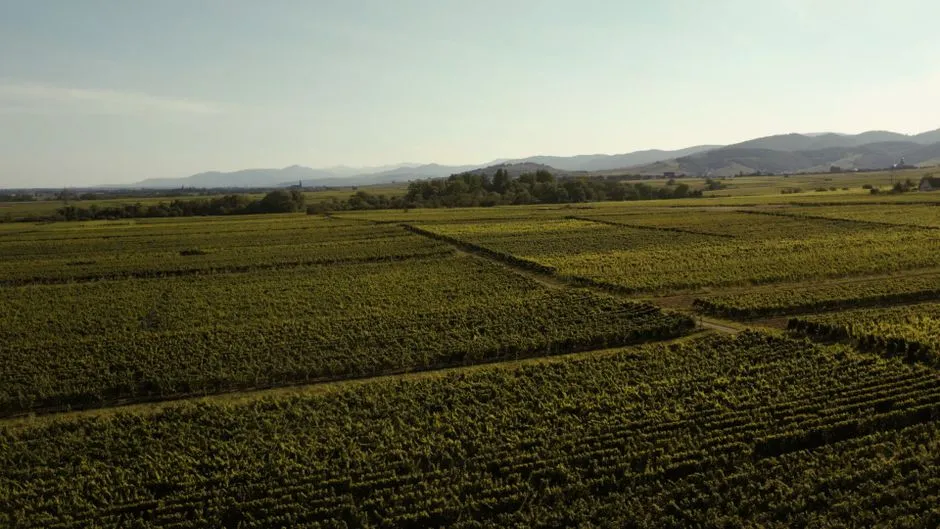
The Annapolis Valley covers 528,000 acres in the northwestern part of the province and is Nova Scotia’s primary wine country. Bordered by the Bay of Fundy to the north and the South Mountain range to the south, this fertile region is famous for its agriculture, particularly apples and vineyards. What makes Annapolis Valley wines so special is the unique climate, with mineral-rich soils and cool coastal breezes from the Bay of Fundy.
Wolfville, originally a farming town, transitioned into a wine hub in the late 20th century as winemakers discovered the region’s fertile soils and cool climate ideal for growing grapes. One of the first wineries was Domaine de Grand-Pré, which opened in 1979. Today the area carries real weight as a wine destination, not just by Canadian standards.
Nova Scotia has its own unique appellation wine, called Tidal Bay. Like Champagne, which can only be made in the Champagne region of France, Tidal Bay is completely unique to Nova Scotia. Nova Scotia has over 20 wineries and vineyards, with at least 12 of them located in the Annapolis Valley. The corridor between Wolfville and Grand-Pré now draws visitors as much for its wine culture as for its history.
The Corridor Today: Living History and Ongoing Significance

Along the shores of the Minas Basin, on the eastern edge of Nova Scotia’s Annapolis Valley, the historic community of Grand-Pré has existed for more than 300 years. Recognized as the birthplace of an enduring culture and a living testament to human ingenuity, Grand-Pré is a connection to a storied past, a present-day place of reconciliation, and a source of inspiration for the future.
One of the Planter descendants was Sir Robert Borden, the eighth Prime Minister of Canada, who was born in Grand-Pré in 1854. Grand-Pré is also Canada’s first designated Historic Rural District. The layers of significance here keep stacking: Acadian settlement, violent displacement, New England resettlement, a founding prime minister, and now a UNESCO-recognized cultural landscape all within a few kilometres of each other.
A 110-kilometre multi-use trail weaves through the Annapolis Valley from Grand-Pré UNESCO World Heritage Site to Annapolis Royal, connecting communities. Today, Wolfville is a popular Nova Scotia road trip stop and has a lively and walkable downtown with sidewalks lined with shops, cafes, restaurants, and even cideries and breweries. The corridor between these two places is no longer just a memory – it’s an active, inhabited landscape where the past and present genuinely coexist.
The story of Wolfville and Grand-Pré is ultimately a story about resilience across many generations. The Acadians built something extraordinary here, lost it violently, and yet their influence never really left. The dykes still stand. The name Grand-Pré still carries its French meaning. The Acadian diaspora still returns. For a stretch of Nova Scotia countryside that might seem quiet on the surface, there is a remarkable amount still alive beneath it.
AI Disclaimer: This article was created with the assistance of AI tools and reviewed by a human editor.